
Map of landslide zones expands
By Amina Nazarli
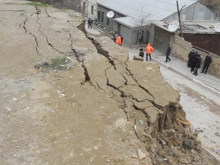
The number of areas facing the risk of landslides and flooding has increased in Azerbaijan.
Sadig Amiraslanov, an official at the Azerbaijani Ecology and Natural Resources Ministry told local media that during the recent months some 11 landslides zones have been observed in Baku, Absheron and regions of the country.
He said a monitoring was held in the southern region and Shamakhi-Ismayilli region during the first 10 days of November.
"Intensive rains caused activation of landslides," he said,
adding that landslides occurred on the Jalilabad-Sadatli road,
Lankaran region's villages and Lerik region's mountain
villages.
Earlier, Nariman Pashayev, Head of the Department of Economic and
Political Geography of the Institute said that about 20 areas in
the capital are considered landslide zones and more than 150,000
people live on the territory.
Experts claim that the number of areas that are prone to landslides in Azerbaijan has increased by four times in the past 24 years.
Scientists believe that people are behind 80 percent of the
landslides by their agricultural activity which increases the risk
of landslides.
--
Amina Nazarli is AzerNews’ staff journalist, follow her on
Twitter: @amina_nazarli
Follow us on Twitter @AzerNewsAz
Here we are to serve you with news right now. It does not cost much, but worth your attention.
Choose to support open, independent, quality journalism and subscribe on a monthly basis.
By subscribing to our online newspaper, you can have full digital access to all news, analysis, and much more.
You can also follow AzerNEWS on Twitter @AzerNewsAz or Facebook @AzerNewsNewspaper
Thank you!