
El Nino seen strengthening as Pacific Ocean’s heat mimics 1997
By Bloomberg
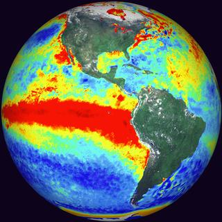
The El Nino taking hold across the Pacific strengthened, according to Australia’s Bureau of Meteorology, citing indexes of sea-surfaces temperatures that showed the same trend for the first time since the event in 1997-1998.
All five NINO indexes, averaged over the past four weeks, exceeded plus 1 degree Celcius, the bureau said in its fortnightly update on Tuesday. That’s the first time that’s occurred since the 1997-1998 El Nino, the bureau said.
Australia this month joined the U.S. and Japan in declaring that the first El Nino since 2010 had begun. The 1997-1998 event was the strongest on record, according to the National Oceanic and Atmospheric Administration. The patterns can bake parts of Asia, hurting crops, while crimping the hurricane season in the Atlantic and bringing more rain across the southern U.S.
“The area of warm anomalies in the tropical Pacific now more resembles a classical El Nino pattern,” the bureau said. “Sea-surface temperatures will remain well above El Nino thresholds at least into the southern hemisphere spring.”
The Australian bureau warned earlier this month the latest event will probably be substantial. The patterns are powered by a warming of the tropical Pacific, and sea-surface and sub- surface temperatures are among the data tracked by forecasters along with air pressure, winds and cloudiness.
Here we are to serve you with news right now. It does not cost much, but worth your attention.
Choose to support open, independent, quality journalism and subscribe on a monthly basis.
By subscribing to our online newspaper, you can have full digital access to all news, analysis, and much more.
You can also follow AzerNEWS on Twitter @AzerNewsAz or Facebook @AzerNewsNewspaper
Thank you!